


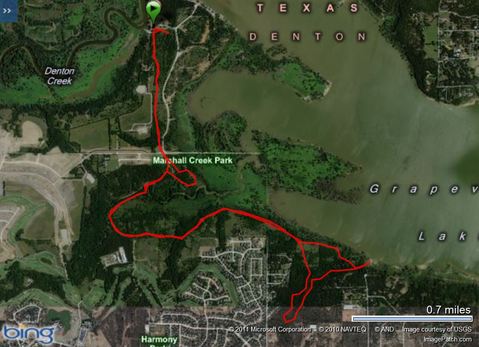
Trophy Club (Marshall Creek) Trail
Lake Grapevine south shore
- Denton County, TexasLength: 1.5-2 miles long (merges into Walnut Grove trail)
Configuration: linear trail system with side loops.
Description: These trails have been there for a long time and are recently improved. Beautiful wide well kept trails near lakeshore. Almost all is wooded. Parallels Marshall Creek for quite a distance. All of the trail that is on the south side of Marshall Creek is the old Walnut Grove trail.
Users: Hikers and equestrians.
Difficulty:
Width: Trail is wide and nicely trimmed.
Footing:
Horseshoes: Trails are very barefoot friendly.
Terrain: Some stretches in woods and some more open.
Challenges: Crossing Marshall Creek.
Near the guard shack there are heavily used motocross ATV trails. They are visible from the parking area, but they are not part of our trail system. The ATVs stay on their designated track.
Weather considerations: *The main gate will be closed and locked during non operational hours. Park hours: 8AM-8PM daily.
Water: Marshall Creek is big wide, and a great watering spot for horses.
Signage: Very well marked, maps available at the kiosk.
Fees: Pay $3 per horse to enter past guard gate into official parking area with facilities. Parking is available outside the gate for no charge, but there isn't much room.
The main gate will be closed and locked during non-operational hours. When the guard shack is not attended you can now pay at our new automated pay station with cash or credit card.
Parking/trail access: There is a designated parking lot with a step over at the north end of trail. Turn left just past guard gate, turn left at the next road to the top of hill with rest rooms on left, the grassy area just past rest rooms is designated equestrian parking. There is step over in the pipe fence at the start of trail.
Trailhead facilities: Bathrooms and a small treed & fenced area with picnic tables near guard gate. No horses allowed in this area. -- Rest rooms are also near equestrian parking.
Managing agency: City of Trophy Club, Mapped, cleared and approved by the US Army Corps of Engineers, Fort Worth District in 2004-5
Volunteer organization:
Proof of negative Coggins required!
Driving Directions: From the intersection of 377 and 114 in Roanoke, go north just past Walmart and go right (east) on Marshall Creek Road. Turn right on Bob Cat Blvd. Left on Trophy Club Drive. Left on Trophy Park Dr. This will take you directly into the park.
Phone: 682-831-4603
Park Office: 817-491-9616
e-mail parksandrec@trophyclub.org
2885 Trophy Park Drive Trophy Club, Texas 76262
CALL AHEAD, as sometimes the park is closed for special events and trails are closed to access.